 Houston-Galveston Area Council Transportation Systems Management & Operations Clearinghouse
 Houston-Galveston Area Council Transportation Systems Management & Operations Clearinghouse
An inventory of existing ITS deployments in the region serves as a baseline for future ITS projects in the region. Houston TranStar, the regional transportation and emergency management center, provides a mechanism through which regional multi-agency cooperation can occur. Houston TranStar offers a central point of ITS data collection, processing, and dissemination for traffic, transit, and emergency management. However, with ITS standards which have evolved in the past decade, smaller sub-regional centers have the opportunity to communicate via center-to-center protocols, either directly or through the Houston TranStar infrastructure.

The National ITS architecture has changed since the last major update of the RITSA in 2008 and moved more towards a service package and view oriented architecture. In the ARC-IT Version 8.0 (2017), there are now 12 Areas of Service (compared to 8 in past architectures), with 133 related service packages (compared to 33) used to represent a slice of the physical view. This slice addressed specific services like traffic signal control. Each service package describe also includes a set of user needs, diagram, functional objects and information flows.
Areas of Service are a group of Service Packages that may be considered as providing similar types of services. The 12 Areas of Service within the architecture include:
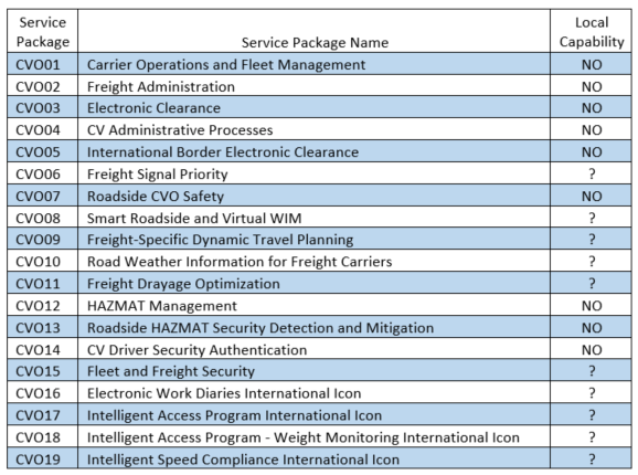
The CVO suite of ITS market packages are intended to provide management, tracking, monitoring, and security functions for commercial vehicle operations. Much of this user service focuses on border crossing elements, but there are opportunities for Houston region deployments in Hazardous Materials (HAZMAT), security and administrative processes. There is very little centralized current ITS activity in this user service area.
The Archived Data Management user service provides an ITS historical data archive. It plugs in the planning, safety, operations, and research communities into ITS data. It may also provide the data collection, processing, utilization, and reporting functions of these communities as they generate and use data generated by ITS systems.

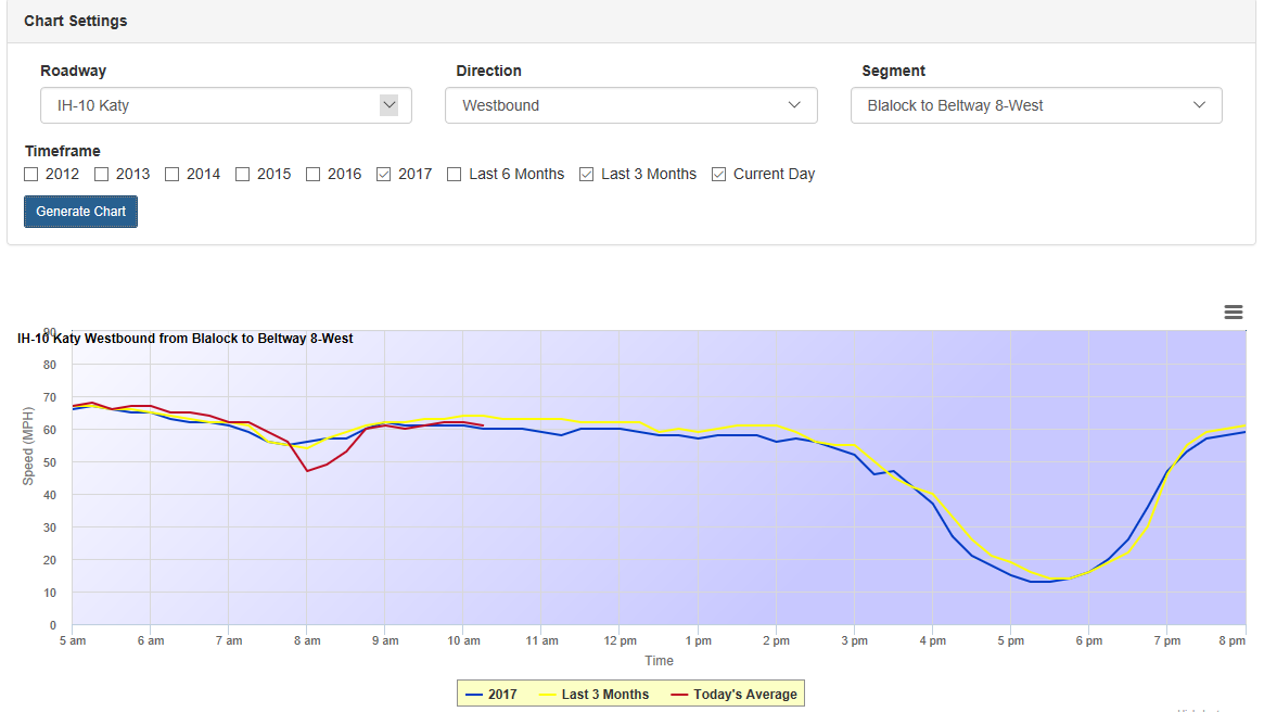
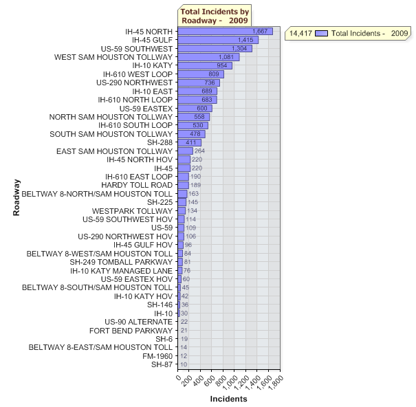
The ITS Data Warehouse includes multiple agency datasets that are in place at various levels at Houston TranStar, particularly with AVI, Bluetooth, and radar sensor data. Steps are being taken to potentially incorporate radar sensor data into the traffic volume count maps Houston on HGAC’s website, but currently that data is consists of static historical data only. ITS data is important to archive so that performance measurement of the ITS systems can take place, as well as the data generated being used for operational and planning purposes, both real-time and retrospective. An example of the existing Houston TranStar Speed Charts is shown below, and an example of Incident Data from incidents managed from Houston TranStar is shown below.
TxDOT archives all non-Lonestar software generated ITS data, including AVI data, Bluetooth-based travel time data, incident data (via RIMS), Motorist Assistance Program data, Tow and Go™ data, and construction/maintenance traveler information data. Currently, the TxDOT Lonestar software does not have archiving capability nor an interface where data generated by it can be archived (particularly dynamic message sign messages). This is a critical flaw in Lonestar, hindering performance measurement capability.
Procuring systems without archival capability is not limited to TxDOT however. Multiple agencies host ITS data archives on local servers, but there is room for improvement in making that data available on a multi-agency or centralized basis. The ITS Virtual Data Warehouse market package would provide a way to access data between Data Warehouses or other ITS Data Archives (e.g., other large multi-agency databases; for example combined emergency management and traffic management database links). Any ITS system that generates data should be archived at some applicable level based on agreed-upon agency operational or planning needs once that data is validated as accurate.
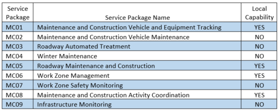
The region has invested in roadway weather information (collaboratively between TxDOT, Harris County, and other agencies) and provides maintenance and construction updates to travelers via broadcast media, roadside dynamic message signs (DMS) and on the Houston TranStar website. Construction activity is readily available for TxDOT and the Harris County Toll Road Authority (HCTRA) via the Houston TranStar website in internet and mobile internet formats. However, City of Houston projects are added into the Roadworks pages on the Houston TranStar website. METRO projects are shown on their website at www.ridemetro.org. Maintenance and construction information is one area where work is underway to create a more centralized point for information, but a true regional effort has not yet been undertaken.
The Houston region has invested heavily in the market packages within the emergency management area. The ITS capability for Motorist Assistance Program (EM04), Port Security and closed-circuit television (CCTV) deployments (EM05), area-alerts using DMS (EM06) and disaster response, recovery, and traveler information systems have all been developed to some level in this region. There are opportunities to link the emergency and transportation management centers in the region on a more strategic and permanent level, but efforts are underway in those areas. Existing ITS systems for emergency management include hurricane traffic control point mapping, rural CCTV and radar sensors, and use of DMS in advance of storms approaching from the Gulf of Mexico.
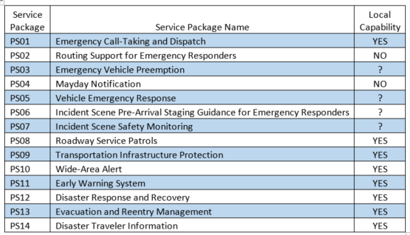
The Houston region has been tested in recent years with significant weather events. Hurricanes Rita and Ike each brought issues of their own (one evacuation, one recovery) and periodic flooding or winter weather events can have a significant impact on transportation in the area.
EM01 provides public safety call-taking and dispatch services, including data communications between field and vehicle. Area police and fire departments have various levels of capability in this area. EM02 may be enabled with more availability of travel time and incident conditions on the arterial roadway, which is currently in development.
Public Transportation ITS falls into four broad categories: enterprise management and operations, transit traveler information, and transit security. Public Transit Management ITS user service services can help automate the functions of public transit systems. Real-time analysis of vehicle and facility status, location of transit vehicles, schedule adherence, and dispatch and operator support are all included in this area. Advanced ITS services include en-route transit information and next-bus arrival info at stops and transit centers. The Public Transport Security user service provides systems that monitor transit assets (facilities, stations and stops, parking lots, and on-board) and generates alarms when necessary.
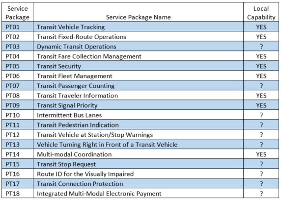
METRO, as the dominant public transportation provider in the region, has instituted numerous ITS systems to support operations. The Integrated Vehicle Operations Management System (IVOMS) monitors bus operations, automatic passenger counting and electronic fare systems (Q-card) are in place, and transit signal priority exists on numerous bus route corridors. METRO employs data radio to provide transit vehicle tracking and on-board security alarms. More than 300 CCTV cameras provide security at METRO facilities, including Park and Rides and transit centers. METRO is seeking ITS deployments in the areas of traveler information and upgrades in capability for AVL.
The region has invested a significant amount of financial resources into developing a robust traffic management ITS capability in the past 20 years. TxDOT, Harris County, City of Houston, and METRO have all contributed towards development of ITS capability at Houston TranStar. Several counties and/or cities have (or plan to have) sub-regional traffic management centers in operation featuring network surveillance, control and management.
Freeway and tollway management systems continue to be developed under the Computerized Transportation Management System (CTMS) Program which is monitored and operated from Houston TranStar. CTMS systems include closed circuit television, vehicle sensors (loops, radar), flow signals, DMS signs, and automatic vehicle identification and location systems (AVI and MAC address matching).
More than 1,000 CCTV cameras are in place for transportation network surveillance and monitoring from multiple agencies. AVI covers more than 900 directional miles of freeways and tollways in the region, and other technologies are quickly enabling monitoring of travel times and speeds on arterials. The regional computerized traffic signal system and I2/Icons traffic signal control systems, along with various other advanced traffic management systems have allowed agencies to achieve a significant improvement in arterial traffic signal control and optimization. However, opportunities still exist to link traffic signal systems across jurisdictions.
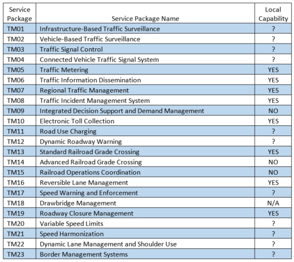
Great strides have been made in this region with standardizing electronic toll collection, with HCTRA operating a large electronic toll collection (ETC) system, including the all-ETC Westpark Tollway, and entering into agreements with Fort Bend County Toll Road Authority and the Houston Airport System to provide processing of transactions on various tollways and parking facilities. METRO and HCTRA do not appear to have agreement on combined operation of the METRO high-occupancy toll lane payment lanes, but there is an opportunity in this region to provide singular regional fare payment (multi-agency, multi-modal systems on one payment platform).
Railroad crossing monitoring has been completed in several prototype evaluations and have been proven successful in monitoring grade crossing status via CCTV and preempt relay. Systems in Houston and Sugar Land have proven the concept viable with communications capability in-place.
Prototype speed monitoring and warning systems have been used at various locations in the region – at direct connector ramps for truck warning, on mainlanes in advance of congested conditions, and in various locations with portable speed trailers.
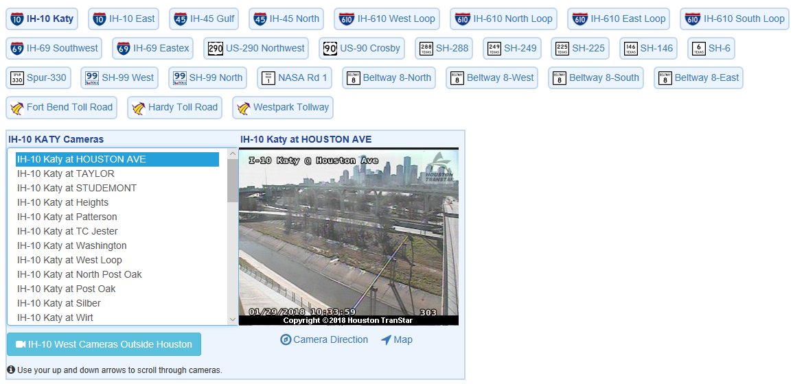
The incident management program is one of the most important functions of Houston TranStar. Detection and verification of incidents is done by operators at TranStar who then dispatch the appropriate resources to the scene. SafeCLEAR (private tow dispatch) also dispatches from the floor at TranStar, linking another incident clearance function to the multi-agency partnership.
In the near- and mid-term ITS deployments in the region, a majority may be traffic management deployments, both in new deployment, replacement of previous generation ITS systems, and with new connections between Houston TranStar and sub-regional centers.
Agencies in this region have long been leaders in providing current traveler information to travelers via broadcast media, information service providers, roadside ITS devices (dynamic message signs and highway advisory radio), and by offering route guidance and trip planner applications (both freeway/tollway and transit). Traveler information systems have traditionally been developed from ITS information collected from the Houston TranStar systems, but traveler information is disseminated by both public and private organizations, which provide reports on local radio and television stations.
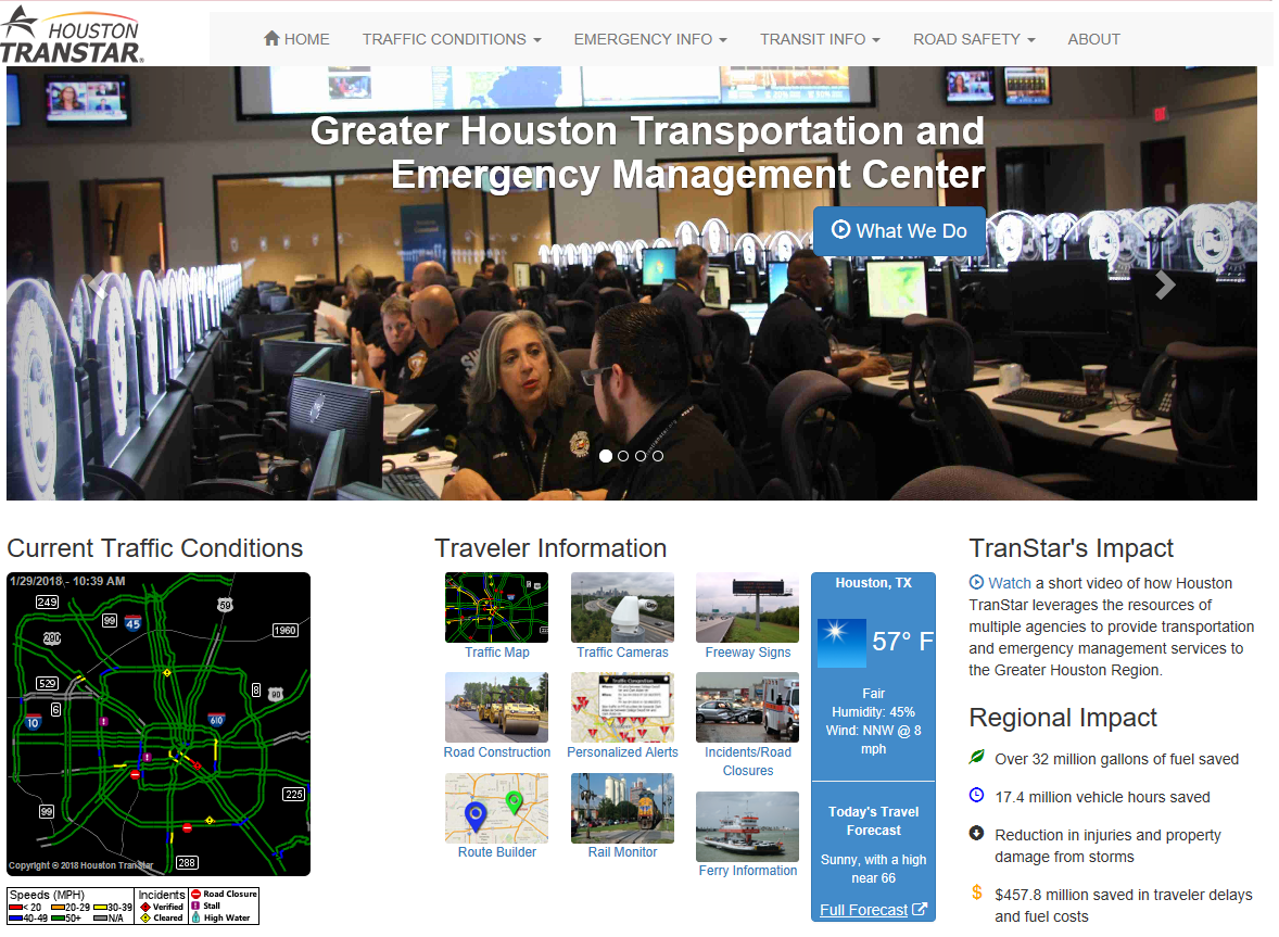
The primary resource used to provide traveler information in the region is via Houston TranStar. Private traffic services have a presence on the floor of Houston TranStar, and provide an interface to private traffic data. Houston TranStar pushes traffic information in the form of broadcast CCTV, and current travel times, speeds, incidents, maintenance and construction activity to broadcast media via the internet and direct feeds.

The Houston TranStar website provides traveler information more than 850,000 unique users per month, and is vital in providing emergency management and transportation management information to more than five million local residents. Personalized incident and travel time information is provided on internet and mobile-internet platforms.
TxDOT, Harris County, and the City of Houston provide CCTV snapshot images from Houston TranStar. METRO provides updates on transit status via their website (which is linked to Houston TranStar’s website).
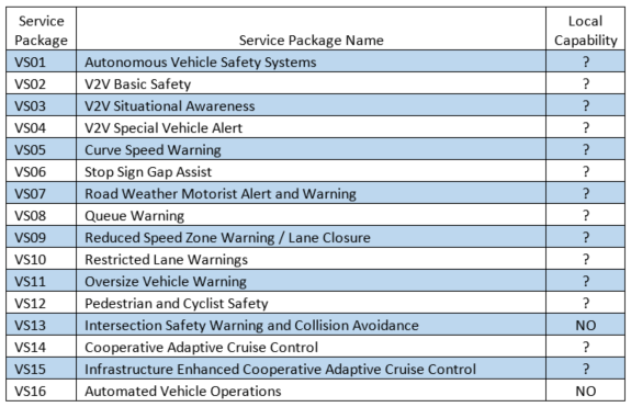
The market packages in the Vehicle Safety User Service Area are largely future applications. AVSS01 is existing on many Original Equipment Manufacturer (OEM) vehicle manufacturers platforms (anti-lock braking system, stability, electrical system malfunction indicators), but the remaining market packages are in research and development at this time. Perhaps the only current implication to existing and planned near- to medium-term ITS deployment is providing communications capacity between center-to-field in adequate amounts to backhaul from the field to various centers. It is very likely that by the time these market packages make their way to widespread use most communications will be wireless.
More about ARC-IT 8.0 can be found in this Key Concepts document: https://local.iteris.com/arc-it/documents/keyconcepts/keyconcepts.pdf
A complete list of Service Packages can be found https://local.iteris.com/arc-it/html/servicepackages/servicepackages-areaspsort.html

The Houston TranStar Consortium is a Partnership of four government agencies responsible for providing transportation management and emergency management services to the Greater Houston Region. TxDOT, METRO, Harris County and City of Houston maintain a presence at Houston TranStar. Houston TranStar was established in 1993 to provide for multi-agency management of the region’s transportation system. It has evolved into a primary resource from which agencies respond to incidents and emergencies in Harris County and beyond. It is the stated mission of Houston TranStar to
… provide highly effective transportation and emergency management services through the combined use of the partners’ collective resources to maximize safety and mobility to the public.
Houston TranStar plays a pivotal role in the travel of people and goods in the greater Houston region, saving motorists more than $5.4 billion in reduced travel time and fuel costs over the 11 years of Center operation from 1997 to 2016.
Houston TranStar uses a three-tiered management structure with representation of each of the four agencies on each committee as shown to the right. The functions of the three committees are:
Houston TranStar is staffed by employees from the member agencies, which support the three levels of management in operating the systems and programs housed in the Center. A small management staff that is responsible for operating and maintaining Houston TranStar facilities, coordinating multi-agency activities, coordinating budget preparation, workshops, meetings, and facility tours, and managing public information activities, coordinates operation of the Center.
At a very high-level view, the ITS activities currently conducted at the center include
Agencies and Departments currently operating from Houston TranStar include:

Detailed lists of TIP and LRP ITS projects may be found at the RITSA website at www.h-gac.com
Other ITS related initiatives specifically mentioned in the 2035 RTP are within Operations Management, one of the four major strategies of the plan, and includes:
ITS Deployment, including
Within the TIP and RTP, some ITS projects are standalone and able to be identified, however many roadway improvement projects include ITS but their descriptions may not include information on what type of ITS elements are included. The current methods of project listing may hinder an assessment of planned and programmed regional ITS investment. The TIP and RTP review highlighted the following needs:
